HPWREN 2025 Year in Review
Introduction
During 2025, HPWREN's predominant focus was on San Diego County, performing upgrades and repairs to maintain rediness for weather extremes and potential wildfire activitiest. As familiar weather challenges returned, high winds, rain, snow, ice, and even atmospheric rivers drove much of the back country on-site maintenance efforts. Alongside these field operations, the HPWREN team also reorganized and enhanced online capabilities significantly, including social media presence, camera access graphical user interface, and related mapping and data access tools for cameras and weather sensors. HPWREN also continued its efforts to migrate major portions of the underlaying infrastructure to Amazon Web Services (AWS), improving backend process management and external user interfaces as well as meeting ever expanding data storage requirements. AWS is now the underlaying production infrastructure upon which HPWREN camera dataflows and web presence resides.
In 2025, Southern California began the year with significant drought conditions, featuring below-average precipitation starting late 2024 and above-average temperatures, both heightening wildfire risk. Early 2025 saw persistent dryness in the region, with negligible rain over several months and elevated fire danger from dry fuels and strong offshore winds. While 2024 had benefited from wetter periods of recent years, 2025 reflected La Niña influences favoring drier winters in Southern California, though later months brought some precipitation relief. This contributed to a pattern of climate variability, with swings between wet and dry periods stressing water resources. Southern California experienced significant wildfire threats in late 2024 and early 2025, driven by extreme dryness and high winds.

Palisades Fire
In January 2025, Southern California was hit by a series of devastating wildfires fueled by extreme Santa Ana winds, with three standout events:
- The Palisades Fire starting on January 7th in the Los Angeles' Pacific Palisades area, burned 23,448 acres, destroyed 6,837 structures, and claimed 12 lives. It was fully contained on January 31.
- The Eaton Fire in Los Angeles' Altadena region, also starting on January 7th, burned over 14,000 acres, destroyed thousands of homes, and caused at least 19 fatalities before reaching full containment on January 31.
- The Border 2 Fire in San Diego's Otay Mountain Wilderness, burned 6,625 acres starting January 23rd, leading to evacuations and school closures but no structural losses or injuries. It was contained by January 30.
Also worth mentioning is the 2024 Airport Fire. This fire, starting September 9th, 2024, near Trabuco Canyon in Orange County, burned 23,562 acres across the Santa Ana mountains. It caused the evacuation of 3,000+ structures and destroyed 120 structures. It also reached the 5,968 foot summit of Santiago Peak, causing major damage to telecommunications and public safety equipment there, including HPWREN cameras, sensors and microwave infrastructure. This triggered significant 2025 HPWREN repairs at that location.
These events stressed firefighting resources amid rapid fire spread. Throughout 2025, elevated fire danger persisted due to dry conditions and temperature extremes, with outlooks warning of potential for further intense events. Against this backdrop of severe dry, hot and windy weather, it was essential that the HPWREN infrastructure remain fully operational to support real‑time situational awareness of any fire outbreaks in our service areas.
Accomplishments
AWS Transition
HPWREN is now well into its multi-year transition to using Amazon Web Services (AWS) for expanded storage, camera image workflow and website support. In fact, most of HPWREN user facing on-line image and data access services are built with AWS technology. Today, AWS supports most of HPWREN's production frontend and backend services.
During 2024 AWS allowed us to achieve cloud based storage stability while concurrently reducing maintenance of and dependence on local storage servers. Having achieved production level storage stability, in 2025 we began transferring our web management and data publishing workloads to the more automated AWS services. In parallel, website (also hosted on AWS) GUI development efforts have provided an alternate and greatly improved user interface, which depends on a significantly simpler architecture, thus further reducing maintenance overhead.
This ultimately resulted in HPWREN's transition to AWS for production camera image integration, user access and web services. Amazon's high availability storage coupled with tiered support levels as well as more automated operational support have greatly benefitted the HPWREN management team and user community. For more details on our ongoing AWS transition, see the news article at https://www.hpwren.ucsd.edu/news/20240512/ or watch the video at https://www.youtube.com/watch?v=enH9dsej9Oc. Thanks again to Calit2's Qualcommm Institute (QI) for their ongoing collaboration and support for this multi-year endeavor, and the ongoing efforts of the QI and Xpertech teams.
AWS Web User Interface Improvements
The HPWREN website, and in particular its camera and sensor interface at https://www.hpwren.ucsd.edu/cameras has undergone significant redesign over the last few years. As summarized in the information ("Info") page of the new HPWREN user interface at https://www.hpwren.ucsd.edu/cameras/help.html:
This user guide describes the features of the new HPWREN web interface deployed since March 2025. Following the migration of HPWREN infrastructure to AWS in 2024, we began working on improving the user experience and utility of the website, the efficiency of camera image and sensor data access, as well as reducing the website complexity. This new HPWREN web interface has been developed by high-school student Daniel Farcas, who has been volunteering for UCSD/HPWREN since summer 2024. The improved user experience is the result of an iterative process with discussions around the utility of the new features, accessibility, and performance. The implementation relies heavily on JavaScript code running on the client browser for advanced image processing and management. Because of underlying technical limitations, some features (e.g., Augmented/Virtual Reality) are only available on specialized devices, such as Meta Quest 3, or mobile phones running Android and the Chrome Browser.
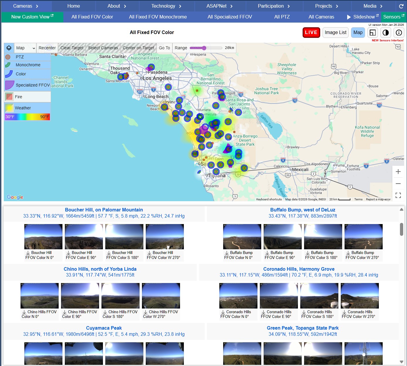
New HPWREN Camera and Sensor Web Interface
This new user interface is most prevalent within the combined cameras and sensors subsection of the website at https://www.hpwren.ucsd.edu/cameras/ which allows the display of those devices within the context of a scalable interactive regional mapping interface. The many features are described in detail in the previously referenced "Info" page, and the most significant are summarized below:
- Integration of interactive image thumbnails and corresponding map interface
- Addition of near real-time weather data visible on the map as well as below selected images (see introductory image above)
- New weather comparison interface when clicking on the "Sensors" tab
- Ease of access (buttons and sliders) for creating visual layouts, scaling and other attributes such as color themes
- Automated slide show of selected (or all) current images
- Map layers allowing for map, terrain and satellite views
- Interactive camera viewshed sighting overlays when dropping or moving pins
- Ability to explore imagery and correlated weather data interactively across time periods
- 360 degree panoramic ("PANO") mode combining multiple site cameras interactively
- User selectable image overlays to improve image interpretation
- Virtual reality support for Meta Quest 3, Quest 3S or other devices supporting WebXR
- A multitude of new keyboard shortcuts
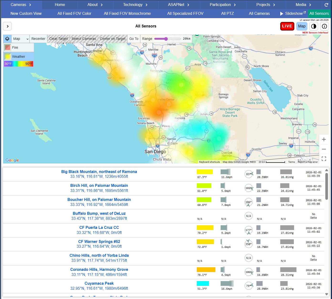
New HPWREN Sensor Interface
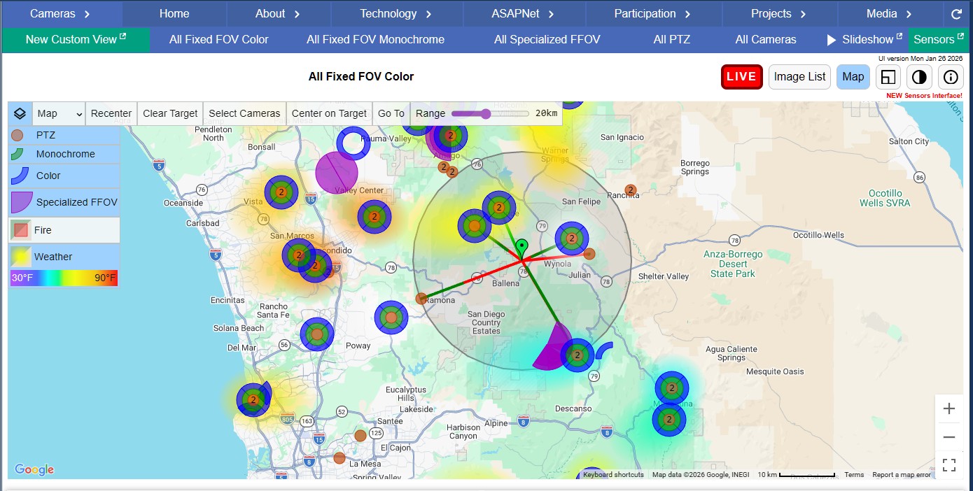
Interactive Viewsheds
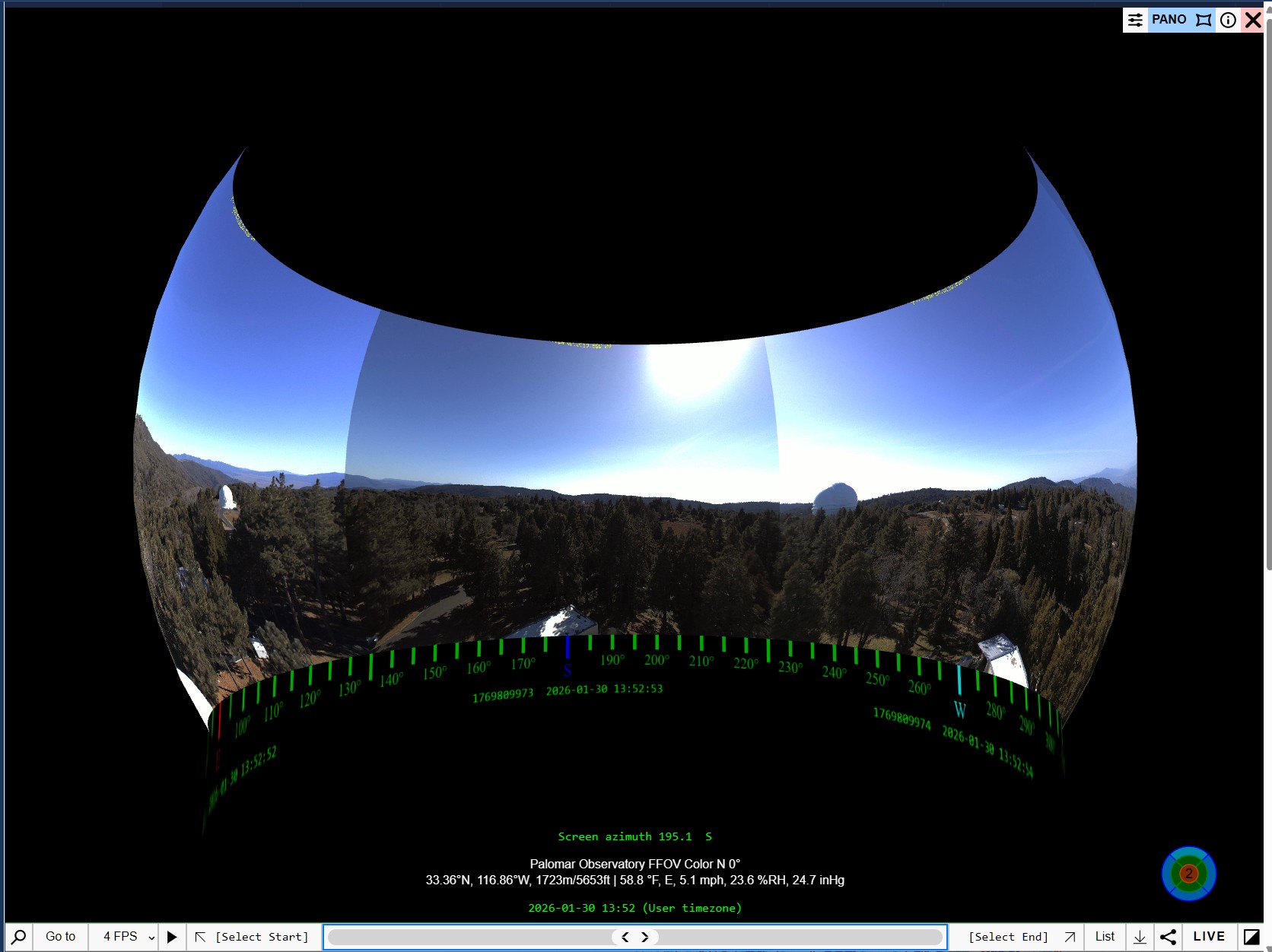
Panoramic Displays
Upgrades and Build-Outs
Site repairs after Airport Fire

HPWREN Camera Covered with Fire Retardant
In late 2024, the previously referenced Airport Fire spread during its September and October duration to Santiago Peak, destroying significant regional IT infrastructure, including HPWREN cameras and communications equipment (microwave links connecting to UCI and Red Mountain sites). The flames literally overran the facilities ... see video of Airport Fire Tower Approach. The damage was extensive and complete.
Santiago Peak towers being overrun
HPWREN had to basically rebuild the facility with new radios, antennas, sensors, router and cameras as well as the entire power, network, and communications control infrastructure (including cabling, conduit, enclosures etc.). Given its remote location as well as the damage, ensuing Winter weather, and extensive equipment replacement processing, not to mention various site inspections and planning meetings with stakeholders, Santiago Peak repairs were not fully completed until almost Fall of 2025.
Camera upgrades
Many sites received replacement or upgraded (mostly PTZ) cameras in 2025. Upgraded sites included Otay Mountain, Cuyamaca Peak, Chapultapec (SDSU), Monument Peak, San Juan Hills, San Clemente Salvador, Boucher Hill, and Rincon Del Diablo. Birch Hill received hyperspectral cameras as well (see related news article at Birch Hill, Palomar Mountain: Imaging at Community Scale).
Link upgrades
Numerous existing radio links were upgraded to use licensed spectrum. Many of them using Siae radios, and some using Ubiquiti, were installed at Mount Soledad, Volcan South, North Peak, Cuyamaca Peak, Redondo Mesa, UCI, SDSU, Santiago Peak, San Marcos Peak, Boucher Hill, Red Mountain (San Diego), and Torrey Pines State Park. Upgraded Fire Station links included those to Valley Center (Station 71), La Jolla Reservation (Station 78), Cuyamaca (Station 51), and Ocotillo Wells (Station 54)
Accordingly, new communications links were installed connecting:
- San Marcos Peak to Red Mountain (San Diego)
- Birch Hill to the Po Muchvol site on La Jolla Reservation
- Birch Hill to La Jolla Reservation via La Jolla Truck Trail TDVNET Relay
- Birch Hill to the Po Muchvol site on La Jolla Reservation
- UCI to Santiago Peak
- Santiago Peak to Red Mountain (San Diego)
Other upgrades and repairs
Battery renewals took place at sites in Los Pinos, Whale Mountain, Bishop, Lake Wohlford, and Mount Soledad. Ice shield repairs or replacements took place on Monument Peak, Boucher Hill, and Birch Hill. Whale Mountain Relay, a communications site connecting Station 87 in Ramona to North Peak, was burned over in the Rancho 3 fire. As of the end of 2025, its rebuild remained a work in progress
IT Infrastructure Improvements
Upgraded switching and management infrastructure
New switching and management equipment was put in place at HPWREN core infrastructure sites. These included SDSU, UCI, SDSC, and SIOCOLO (at Scripps Institution of Oceanography), computing and networking facilities. Upgrades included new out-of-band network connections, switch interface bandwidth upgrades (up to 800 Gbps) and new OpenGear management equipment. These new Opengear console servers now support remote management for HPWREN network and server equipment. They are used in key locations to give secure remote (OOB - Out of Band) console access, power control, and monitoring to support the management of HPWREN routers, switches, firewalls, and servers, even when the primary network is down.
ASAPNet Infrastructure Improvements
The Advanced Situational Awareness for Public Safety Network (ASAPNet) is a crucial wireless network designed to serve fire stations, particularly in the remote areas of San Diego county.
ASAPNet POP Redesign
ASAPNet fire station equipment has evolved in an ad-hoc fashion since its initial rollout in 2012. Efforts are now underway to redesign and unify the HPWREN Point of Presence (POP) at served stations in an effort to return them to a common hardware baseline, provide more enhanced monitoring of network health all the way to the station connection, and clarify the demarcation point between HPWREN and San Diego County (or CalFire or USFS) responsibility.
Partial results of these ongoing efforts to date include the following as stations are upgraded:
- Installing Ubiquiti Dream machines or equivalent smart routers
- Installing custom Sunwize Fire enclosures ("E-boxes") for holding and protecting key control electronics
- Adding Public Service (WiFi) Access Points
- Replacing dumb switches with smart (more manageable) switches
- Standardizing equipment for ease of service
Other ASAPNet related upgrades
- Descanso (Station 44) upgraded communications link to Cuyamaca Peak
- Cuyamaca (Station 51) upgraded communications link to North Peak and new Public Service Access Point (PSAP)
- Valley Center (Station 71) upgraded communications link to Boucher Hill
- Public Service Access Point addition for Monument Peak (Station 78)
Partnerships and Support
Partnership with ALERTCalifornia
ALERTCalifornia, a program dedicated to wildfire monitoring and research in California, partners with HPWREN to enhance its capabilities in understanding and managing wildfires and other natural disasters across the state's vast and diverse terrain. This partnership is crucial given California's expansive area of over 163,000 square miles, which presents unique challenges for fire management and research. The multidisciplinary team at ALERTCalifornia, based at UC San Diego's Scripps Institution of Oceanography, Jacobs School of Engineering, and Qualcomm Institute, works closely with various state partners. This partnership underscores the program's commitment to state-specific needs, filling knowledge gaps, and providing actionable data for informed management decisions in the face of natural disasters.
HPWREN plays a dual role in this collaboration. First, it hosts 100+ ALERTCalifornia Pan-Tilt-Zoom cameras, integral to monitoring and data collection. Second, HPWREN manages a portion of ALERTCalifornia's networking system, ensuring efficient data transmission and communication.
In support of the growing ALERTCalifornia community, HPWREN continues to provide high quality Internet connectivity using fixed wide area wireless technology connected to multiple regional Internet gateways at sites in San Diego, Orange, Los Angeles, Riverside and Santa Barbara Counties.
By the end of 2025, HPWREN was supporting over 475 fixed and PTZ public safety cameras.
HPWREN Partners:
- ALERTCalifornia - https://alertcalifornia.org/
- California State Parks - https://parks.ca.gov/
- Caltech's Palomar Observatory - https://sites.astro.caltech.edu/palomar/
- NASA's International Laser Ranging Service MOBLAS 4 Satellite Laser Ranging Station on Mt. Laguna - https://ilrs.gsfc.nasa.gov/network/stations/active/MONL_station_info.html
- San Diego County Fire Protection District - https://www.sandiegocounty.gov/content/sdc/sdcfa.html
- San Diego Gas & Electric - https://www.sdge.com/
- San Diego State University's Mount Laguna Observatory and Field Stations Program - https://astronomy.sdsu.edu/mount-laguna-observatory-facilities/
- UC San Diego, California Institute for Telecommunications and Information Technology (Calit2) Qualcomm Institute - https://qi.ucsd.edu/
- UC San Diego, San Diego Supercomputer Center - https://www.sdsc.edu/
- UC San Diego, Scripps Institution of Oceanography, Institute of Geophysics and Planetary Physics - https://igpp.ucsd.edu/
- UNAVCO - https://www.unavco.org/
- University of California Santa Barbara's Earth Research Institute - https://www.eri.ucsb.edu/
Public Safety
Community Resource Centers
HPWREN continues support for SDG&E back county resource centers providing Internet access. These Community centers are activated as part of the Public Safety Program when power is dropped in the area during red flag warnings. These Community Centers include:
- Dulzura Community Center - Internet access provided via Lyons Peak
- Lake Morena Community Church - Internet access provided via Los Pinos
- Potrero Community Center - Internet access provided via Los Pinos
- Pine Valley Improvement Club - Internet access provided via Cuyamaca Peak
ASAPNET and PSAP Initiatives
ASAPNet is a crucial wireless network designed to serve fire stations, particularly in the remote areas of San Diego County. Functioning as an extension of the University of California San Diego's High Performance Wireless Research and Education Network (HPWREN), ASAPNet relies on HPWREN as its foundational wide area network. This network is expansive, encompassing 66 fire station sites and 12 relay sites, all of which originate from 16 mountaintops across San Diego County.
Currently, seven sites have been upgraded with Public Safety (WiFi) Access Points (PSAP). During 2025, improvements were made to HPWREN backbone radios and networking in preparation for extending PSAP coverage to additional fire stations and appropriate HPWREN points of presence.
Fire Lookout Support
Within San Diego County, Forest Fire Lookout Association of San Diego County (https://www.ffla-sandiego.org/) volunteers operate two active Fire Lookout towers: High Point (http://nhlr.org/lookouts/us/ca/high-point-lookout/) and Boucher Hill (http://nhlr.org/lookouts/us/ca/boucher-hill-lookout/) on Palomar Mountain. A third tower, staffed by Forest Service personnel, is situated in Southern San Diego on Los Pinos (http://nhlr.org/lookouts/us/ca/los-pinos-lookout/). HPWREN also connects Black Mountain Lookout (http://nhlr.org/lookouts/us/ca/black-mountain-lookout-san-bernadino-nf/) in the San Bernardino National Forest which is staffed by the Southern California Mountains Foundation Fire Lookouts Program (https://mountainsfoundation.org/programs/fire-lookouts/). All these towers utilize HPWREN equipment to facilitate connections to the Internet and leverage their resources, thereby ensuring dependable external communications. For more details see https://www.hpwren.ucsd.edu/news/20240214/.

The View North from Black Mountain Lookout (Riverside County)
Fire Fighting and Forensic Support
During active incidents, the HPWREN cameras and weather sensors offer Emergency Operations Center managers live (or near real-time) situational awareness to help monitor fire progression, track asset locations, and observe dynamic behaviors such as flames traversing canyons, mountain ridges, and other natural or man-made features. HPWREN archival imagery can also provide additional information in support of after action reports or other later investigations.
An often overlooked benefit of HPWREN, with its decades of archival data, is support for public safety or research activities over the longer term. HPWREN provides invaluable real-time and archival camera image data from over 400 cameras positioned on Southern California mountaintops, delivering critical utility across wildfire management. Past images enable detailed forensics to pinpoint where, when, and how fires ignite, while also supporting sophisticated wildfire modeling to analyze how blazes move, grow, and respond to firefighting efforts. Earth and Life Science research can also benefit from the plethora of available imagery.
One forensic example of such usage had to do with the "Border 2" fire, which burned 6,625 acres in the Otay Mountain Wilderness from January 23rd to the 30th, 2025. Based on images from one of the more light and near-IR sensitive monochrome HPWREN fixed field of view cameras, it was possible to revise the ignition time of the Border 2 fire to more than 12 hours prior to the previously assumed ignition point of about 13:23 on 23 January 2025. Instead, the fire started the night before at, or prior to, 00:45. Using images taken of the fire, a video was created to pinpoint a more accurate ignition timing. For details, see Border 2 Fire on Otay Mountain. This time-lapse video shows the area from midnight to 15:00. To create better visibility, the basic video was overlaid with a semi-transparent baseline image taken from shortly after the daytime flareup, and added a small visible plume. This helped with comparing the locations at the times when the fire was visible, to determine that they were indeed the same. It also provided for a better view of location specifics, as, without the overlay, the photos appeared mostly black at the location of ignition.
Another example from the January 1, 2025 start of the Lachman Fire which was the precursor to the January 7, 2025 Palisades Fire:

Start of the Lachman Fire, January 1, 2025
Start of the Palisades Fire, January 7, 2025
Other customizations are possible with creative stitching of images together, illustrated for example with Cloud Formations around Toro Peak.
A good example of past imagery revealing wildfire dynamics occurred in 2024. HPWREN camera images assisted Professor Rick McRae, University of New South Wales Canberra, in validating a wildfire behavior dynamic that he discovered many years earlier and which was subsequently known as Vorticity-driven Lateral Spread (VLS). Quantifying the specific dynamics of this behavior was a challenge as there were so few "snapshots" from available satellites or airborne line-scanners, let alone actual photographs. Over two decades they gathered reports, did post-fire analyses, did wind tunnel tests, and hi-res computer modelling. VLS had remained stubbornly difficult to parameterize in detail, until January 9th, 2024, when his team saw what HPWREN recorded on Santiago Peak during the spread of the Airport Fire.
On the afternoon of the 9th, with an ENE wind, a VLS event climbed the hill from the south and just skirted past the site. This footage contained plume dynamics details in high resolution never before seen. These images raised new hypotheses about how spot-fires are caused. That night the next two ranges to the west carried sequential VLS events from S to N. On the 10th, the next ridge to the east carried a VLS event S to N with an ENE wind. This put the HPWREN cameras right inside the spotting zone. This provided never-before-seen close-up details of the spotting process.
For further details, see the writeup at http://www.highfirerisk.com.au/vls/.
Public Outreach
The many ways we have reached out to the
public this year include:
- Posted numerous interesting and informative YouTube videos.
- See 30 or so 2025 videos (animations, split screens, surround views, etc.) of fires and interesting events captured by HPWREN cameras at https://www.youtube.com/user/hpwren/videos.
- Posted new content on the website https://www.hpwren.ucsd.edu/
- Read more about HPWREN accomplishments, cameras, and fire monitoring, in 2025 news articles at https://www.hpwren.ucsd.edu/news/index-2025.html .
- Boosted social media presence and increased followings on:
News Articles
Articles describing 2025 research and development activities include:
- A Multi-Wavelength Approach to Wildfire and Air Quality Monitoring
- Birch Hill, Palomar Mountain: Imaging the Invisible at Community Scale
- Improvements to HPWREN Data Management and User Interface via AWS
- The Lunar Analemma
The Rincon Fire Experiment: Using wide-area hyperspectral imaging at Birch Hill for the rapid identification and analysis of small events.
Context summary for the work with hyperspectral cameras on Palomar Mountain.
Read about the new HPWREN data management tools and user interface as well as the story of our ongoing AWS migration.
Robert Quimby, a professor of Astronomy at San Diego State University has used images from the east-facing HPWREN camera at the Mount Laguna Observatory to show how the Moon's position in the sky changes as it moves through its orbit. A plot showing the apparent position of the Moon every 24 hours and 50 minutes for 1 month is called the Lunar Analemma.
Mail List Announcements / Interesting Videos
Sent to l2@hpwren.ucsd.edu (to sign up for these announcements send a request to fback@hpwren.ucsd.edu).
- 1/7/25: Border 1 Fire -- This video shows a time lapse from before the Border 1 fire started on Otay Mountain in San Diego on New Year's eve (12/31/24). Taken from the HPWREN Otay Mountain east-pointing camera.
- 1/7/25: Eaton Fire -- Eaton Fire 180+ degree view from the Mount Wilson Observatory
- 1/8/25: Palisades Fire -- Timelapse of the Palisades Fire near Los Angelas as seen from Green Peak, showing early progression of the fire
- 1/9/25: Palisades Fire, 360 degrees surround view
- 1/13/25: New video on HPWREN New Camera User Interface
- 1/23/25: Border 2 Fire on Otay Mountain -- This time-lapse video shows the Border 2 Fire from before its wispy start at 13:23 or before, then progresses to burn on top of Otay Mountain. The video is shown as two opposing 180 degree views on top of Otay Mountain, with some overlap.
- 2/12/25: Additional Border 2 Fire Imagery
- 5/12/25: Cloud formations around Toro Peak -- mid-May, 2025
- 8/2/25: Updates to Data Management Interface via AWS
- 9/17/25: Hyperspectral Cameras: Imaging the Invisible at Community Scale
- 9/17/25: Hyperspectral Cameras: A Multi-Wavelength Approach to Wildfire and Air Quality Monitoring
- 9/29/25: Vandenberg Rocket Launch
- 11/14/25: Aurora Borealis as seen from San Diego
Aurora Borealis as seen from Monument Peak
The Aurora Borealis, or Northern Lights, is a spectacular natural light display caused by charged particles from the sun colliding with Earth's atmosphere, creating glowing curtains of green, purple, and red high above the poles. Normally visible only in high-latitude regions such as Alaska or Scandinavia, a powerful geomagnetic storm around November 2025 triggered by intense solar activity expanded the auroral visibility far southward. This rare event made the lights visible from northern San Diego County skies and were captured by multiple HPWREN cameras.

Aurora Borealis as seen from Iron Horse Vinyards

Aurora Borealis as seen from Cuyamaca Peak

Collage of Aurora Borealis
And finally, for your viewing pleasure, we end the year in review with a December 29th, 2025 sunset as seen from UCSD's Theater District Living and Learning building.
Sunset as seen from UCSD at the end of 2025